North Platte River, CO – April 23, 2006
Posted on November 11, 2006
I have spent some time hiking along and around the North Platte River close to where it crosses the Colorado and Wyoming border. This particular day I stayed high in the hills above the river to avoid the ticks that were starting to appear. Generally, they can be bad for a few weeks until things start to dry out a little. If you get away from the water, you get away from the ticks. So, what I did was take off from the parking lot of the North Gate access point and just head up into the hills to the north.
Before I go any further in the trip’s description, here is my standard comment. Please check my photo galleries here for all the larger and higher quality photos for this trip. In addition, you can view a topo map here and a Google Earth map here (you may need to adjust the scale bar on the left side of the Google map). All links open a new browser window.
If I went later on in the summer after things had dried off along the river, I would expect the tick situation would not be too bad. But, always something you should check for once you get home. Even while hiking in what you think may be a “ticky” area, you can glance down at your legs occasionally to see if there is a tick that managed to “make contact.”
You can easily manage finding your way up the hills. It’s not very steep and the sage brush is low and scattered. I did “cheat” a little by starting off on a little self-guided trail that begins at the parking lot. It’s a loop, so once I got to the top of the trail’s loop I just started hiking up the hill. Once I reached the top of the first ridge, I continued along the ridge all the way to the highest point (about a mile) that would allow me to view a 360 degree area around me.

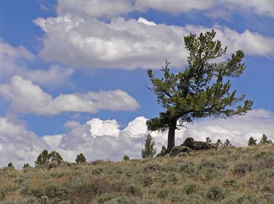
At this time of the year the wild flowers are just starting to appear, so if you keep an eye open, you can see some nice examples of pasque, cactus, and other early flowering plants. The weather can be quite nice at this time of year, as it was for this hike. Or, it can be cold, windy, and wet. So, be prepared.

The farther up the ridge I went, I began to hit stands of aspen and pine. Occasionally there would be a small meadow to cross. Along with some early flowers, I managed to walk up to a herd of deer. Due to my being relatively quiet and the wind being in my favor, they did not take alarm. I spent some time quietly taking some photos of the deer.

After a while I made enough noise and movement that they decided to move on to a more secure location (away from the stupid human : )

There was a 4 wheel drive road that ran along the ridge-top. It seemed to keep on going to the north, but I ran out of time for further exploration. Maybe another day.
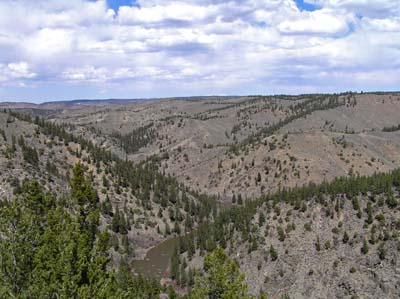
I did enjoy a great view from the top. It allowed me to get photos in all directions. Far away to the north I could see (just barely) the Snowy Range in Wyoming still covered with snow. I could also see a good portion of the North Platte River canyon (also known, I believe, as the North Gate Canyon). To the east (left) of the river is the Platte River Wilderness Area.
All in all a very enjoyable place for an early spring hike and not have to worry about either the snow or the ticks along the river.
– Geoff Weatherford
