Lake Katherine Trail, Mt. Zirkel Wilderness Area, CO on July 8, 2005
Posted January 28, 2007
The Mount Zirkel Wilderness area is situated along the continental divide in northern Colorado. Just west of Walden, CO. Or, if the metropolis of Walden is a place you have not heard about, the wilderness area is just east of Steamboat Springs, CO. It is a 2.5 hour drive to get to the Mt. Zirkel wilderness from Fort Collins, CO. Which means that in the summer you can leave Fort Collins after work on a Friday and easily make a trailhead camp before dark. Perfect.
Before I go any further in the trip’s description, here is my standard comment. Please check my photo galleries here for all the larger and higher quality photos for this trip. In addition, you can view a topo map of the Lake Katherine TH here and a topo map here that shows where the trail contiues up to the continental divide. A Google Earth map can be found here (you may need to adjust the scale bar on the left side of the Google map). All links open a new browser window.
I need to make a couple of things clear first. One thing is that getting to the trailheads for this wilderness area can be a little tricky. This is because some of them are only approachable using access roads through private ranch land.
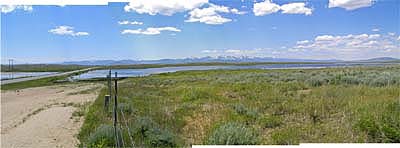
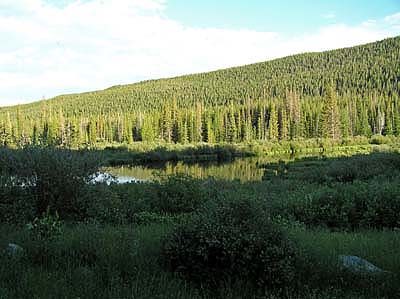
What this translates to is that you have to have a map and be careful about following any and all signs that might point you to the correct place. That said, this does help ensure (I think) the rather under-utilization of a very pretty wilderness area. Actually, its very pretty even before you get into the wilderness area itself. The Routt National Forest around the trailhead (and in the surrounding area) can provide many hours of great hiking without ever stepping into the Mt. Zirkel wilderness itself. Here is a crude panorama of the Mt. Zirkel wilderness area as I was leaving Walden, CO to “find” the trailhead.
The other issue is that, well, ummm, I never made it to Lake Katherine : ) What happened is I got going on the trail and it was so pretty that I decided to bypass Lake Katherine itself and continue all the way up to the continental divide. Darn, that means I’ll have to go back some time just to see Lake Katherine.
Hmmm. I think I should add that my decision to change plans is not something I would ever recommend someone doing. That is, you should have a specific destination in mind, let someone know what that destination is, and then stick with it. Otherwise, if you change your destination and have an accident, then it will be difficult to locate your new position by your friends, the forest service, or whoever. While I did see that forest service trail crew, they were the only other people I saw the entire time on the trail.
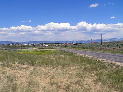
As I stated, this area is situated just west of Walden, CO. I find particular pleasure in this due to the fact that Walden itself is such a neat place to visit. Situated in North Park (a rather large area surrounded by moutains), with the majority of people involved in ranching, the town is a great place to wind down from the hustle and bustle of cities. A person who wished to have a enjoyable vacation could do worse than to get a motel room in Walden and take day trips to the various surrounding mountains. There is fishing, hiking, wildlife (moose : ), and kayak/rafting in the area. Great place. Here is a photo looking back at Walden.
Anyway, I wound my way through the back roads until I “found” the Lake Katherine trailhead. Hay season was in full motion, the pastures and meadows were all green, and there were very few people. I got to the trailhead within a couple of hours of sunset so there was time to walk around and enjoy the scenary before it got dark. Lots of beaver ponds made for lots of ducks and small wildlife activity, but also allowed for a nice environment for mosquitos. Not too bad, but most people will be happy to put on a little repellent. I normally just use clothing to cover my skin in case of mosquitos.
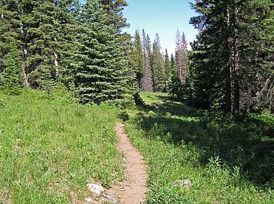
Got up the next morning and started up the trail. The trail does climb (obviously, since you end up on top of the continental divide), but it’s a very pleasant gain in altitude. I think you start at approximately 9,000 feet in elevation at the TH, and end up around 11,000 feet on the divide. But, thats spread over 3-4 miles with only the last half mile or so being a steep pitch. Anyway, the trail winds through lots of meadows.
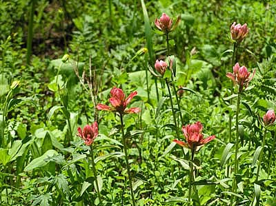
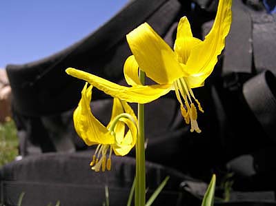
At the time of my hike, the flowering season was in full swing and it was hard to keep my mind on the trail.
On the way up the trail, fairly close to the middle of the last steep pitch, I passed a forest service trail crew working on the trail. They told me that they only get to each trail about once every 3 years (due to budget constraints). I found the trail to be very well kept and easy walking.
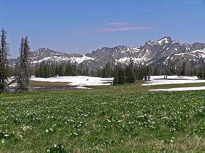
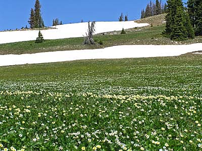
Up on top, the above timberline meadows were a relatively solid carpet of flowers. I tried being selective of my photos, but finally gave up and just pointed the camera everywhere to get a photo. It really was incredible. The weather was very nice, warm with only a slight breeze. It’s worth noting that I was lucky that we had a mild winter and early summer. Otherwise, this would have all been covered with snow at this time of the year. So, if you are planning a trip to this area you may want to time it differently than me depending on the snow pack. And, as always, keep an eye on the weather since it can change rapidly. The top of the continental divide is normally not a good place to be caught in a storm.
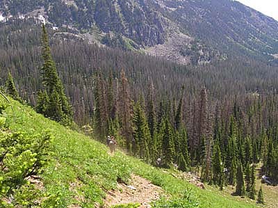
I took a late lunch break, took photos of the surrounding moutains (including the forest service crew in the distance as they were inspecting the surrounding area), took way too many flower pictures,
and then decided it was time to head back to my truck. It was a difficult decision to head back down, but I like to get back to town prior to dark if possible. And, even though the temperature had been quite mild, I knew that the temperatures would start dropping as the sun went down. With the breeze on top of the lowering temperatures, it would get chilly real fast. For some reason, the hike back down the trail went much faster than coming up. Go figure : )
All in all, an outstanding hike in some very pretty country. I look forward to coming back again.
– Geoff Weatherford

I enjoyed your slideshow and comments, in the early 70’s
I camped and fished with my uncle at the end of the road
on Lone Pine Creek and would hike up to Lake Katherine
for an afternoon of fishing.I recall that someone had
fallen into the lake and had not as yet been recoverd
but later we heard that the body was recovered.
We would enjoy a week of fishing for Brookies in the
beaver in the Lone Pine Creek valley, also recall
a BearCreek and really large beaver ponds over a ridge to the north of Lone Pine, we one spotted a black bear
along that ridge. I am now 72 but 3 of the best weeks
of my life were spent on Lone Pine and would like to
one day see it again.
sincerely
Dennis Waite
Dennis,
Thanks for stopping by and having a look. I want to go back myself again someday. Very lovely area.
The one thing that may have changed since you went was that the number of beetle killed pine trees have increased dramatically. So, one of these days there will probably be a fire that will run through that entire area. If you can make it back sometime soon, that would be a good idea.
Thanks,
Geoff Weatherford
I have camped and hiked in this area for 15 years. It is a wonderful area full of scenic beauty and wildlife.
Mike,
Yep, awesome area. I spend a lot of time in the Zirkels every summer.
Thanks for visiting my site.
Geoff Weatherford
This is so cool! I haven’t had time to read the whole front page,but WOW what an awesome hike!! I recently got into photography and we (my husband) and I are planning a backpack trip to Mt. Zirkel. We were wondering when is the best time to see the wildflowers in full bloom? Would love to see gobs of wildlife as well. We currently live in CO.
Thanks so much
SheriJ
Well, the earlier the better. Kinda depends on the season (lots of snow?) that year. Probably any time in July (assuming the snow has melted enough to let you get up the trails). By August it can begin to get a little dry and the flowers won’t be so abundant (again, depends on the year). That said, you will see some wildflowers all summer, just a times you will see more than at others.
Good times would be middle to end of July (the hike above was end of the first week in July, but some years the snow will still be covering up that high country in the photos).
Have fun and take lots of photos : )
– Geoff Weatherford
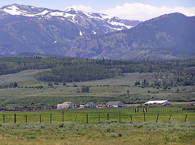
LOL! The ranch in your first picture is where my best friend and his family live! You might know them, the Gollobith family. I have a ton of great memories out there! Mostly of us camping and branding calves!
Heading up on Saturday! Great pics
We are planning a trip to Lake Katherine in mid August. We tried to find it 32 years ago! but the trail was snow covered and we lost our way, never reaching the lake. So getting there has joined our “bucket list” and we are going to try again. So for anyone familiar with this trail I have a couple of key questions…
1) how is the area now after the fires? not sure how close it was to this
2) we’d like to bring our dog, she’s pretty fit so should be fine. I am a bit worried about high log crossings though. Is that what you have to take over the creek?or is there a bridge or is wading through a possibility? That’s what we did last time, pretty trecherous I recall…and I’d prefer not to do that again! so anyone please let us know the severity of a creek crossing.
3) at a leisurely pace (being with a dog, and not spring chickens ourselves anymore) how long does it comfortably take from the trailhead to the lake?
4) are there campsites at the lake only, or some on the way too? I think I read they can’t be reserved so I guess we’d take our chances…
any and all advice welcome…..thanks! kkrebsbach@rsandk.com
Kay,
Here is a little secret.� I’ve been on the Lake Katherine trail more than once, but never made it to Lake Katherine.� I’ve always gone past the fork in the trail that leads to Lake Katherine and headed up the trail to the continental divide.� So, I’m a little at a loss for some of your questions, but I’ll answer the best I can. 1.� Fire – this area was not close to the recent fire activity in Colorado.� So, should be no problem in that area.� Although up until this weekend, I’m sure all campfires have been banned.� Stoves only.� But, may want to contact the Forest Service to make sure that there have been no other restrictions (such as closing down the entire area; it got really dry).� We did get some rain this weekend, so hopefully that eased up the restrictions.
2.� Creek crossing – since I never took the fork in the trail, I did not see what type of crossing was available.� It could be a bridge, but may be only a log.� Or, may be even less (if spring floods washed away a log).� Again, the forest service could help in that area.� That said, if you are going in August, more than likely crossing the stream will be a non-issue (unless the weather changes to more rain) even with out a bridge or log.� Things have dried up a bit by that time of the summer and the water levels are usually pretty low and slow.�
3.� Time – I think it is only 3-4 miles one way.� So, even at my speed of “take a photo every step of the way” (say, 1 mile per hour), probably 4 hours tops one way.� Probably less unless you just want to go real slow (which may be the case with heavy packs and if you are not used to high altitudes).�
4.� Campsites – It’s a wilderness area, so camp where ever you wish.� The only rules (normally) are you need to be 50-100 feet (or, is it yards?) from the stream.� There are occassional differences, but any rules will be posted at the beginning of the trail (and, if you check with the forest service in Walden they can fill you in on any special rules for the area/lake).� There “may” be some rules about dogs such as they have to be on a leash.� But, not sure about that since I never have a dog with me.� Again, there may be special rules about open campfires.� But generally it’s pitch your tent where ever you wish.� And, yes, no reservations allowed : )
Hope that helps.� Should be a lot of fun.� Ummm, not that you will need it, but remember the mosquito repellent.� You know, just in case.
Thanks,
GeoffW
Great advice, thanks so much for all of it! Colorado is so beautiful, it won’t be hard to have fun!
Just got back from three days at the lake. Trail is a little steep in the last part but we met two guys bring down their 16 foot canoe. No problem on any creek crossing and we did get a short rainshower with thunder each afternoon. Also took a day hike around to Big Horn Lake and it is a tougher hike. Down trees and muddy places. It is a little over a mile from the fork in the trail to either Katherine or Big Horn. Lots of nice camping sites on the north side of Katherine but I only caught one fish! I have asked around about the old rock dam at Katherine as well as an old log cabin on the south side. One of the Rangers thought it was from logging operations but don’t think there were any mines in the area.
Hey, thanks for the update on your trip.� Interesting.�� I don’t think I’m going to make it there this summer.� But, I’ll be back eventually.� Probably next summer when I think I’ll be able to have everything I need for over night trips.� I’m definitely not surprised about the rain showers.� I’ve only been hiking in the Zirkels 2 or 3 times that were “dry” hikes : )
Thanks,
GeoffW
________________________________